WaterTribeTM Ultra Marathon (UM)
Tampa Bay To Stump Pass at Cape Haze Marina In Sea Kayaks, Canoes and Small Boats
The next Ultra Marathon is
Saturday, March 13, 2027. There is registration and equipment
inspection on, Friday, March 12, 2027, prior to starting.
Cost is $295.00
for the captain and $295.00 for
crew members if any.
Billing starts
Friday, January 1, 2027
The Registration and Payment Deadline is
Sunday, January 31, 2027 at noon.
Due to the exteme commitment for this race late registration and/or late payments will not be allowed. We recommend that you commit to this race early so you have plenty of time for planning, training, and preparation. Pay early in the payment cycle. You can get a full refund up until January 23 at noon. No refunds after that
date and time.
All WaterTribe events are dangerous events as defined by Florida law and common
sense. You are responsible for your own safety. You must read and
understand the warning before you register for this event.
The Ultra Marathon is an unsupported, expedition style adventure race for kayaks,
canoes, and small boats. The distance is roughly 62 miles depending on your course
selection. There is a time limit of 2 days or less. Your safety and well being are
completely up to you.
Unsupported means that there are no safety boats or support crews to help you during
the race. You are not allowed to have a support crew follow you or meet you during
the race. It is OK to have family or friends meet you at the official checkpoints,
but they cannot provide anything other than emotional support. See the official
WaterTribe rules for more details.
Expedition style means that you must carry the same type of equipment and supplies
that you would carry on a major expedition lasting 4 weeks or more. Camping equipment,
food, water, safety, communication, etc. is required. See the Rules and Warning
link at the top of this page
for the official required equipment list for more details.
Although this is a race, many participants are more interesting in cruising and
adventure. Whether you are a cruiser or racer is up to you. Just getting to the
starting line is a major accomplishment and only about 40% of starters are able
to finish. You should be an expert kayaker and/or sailor before
you consider this challenge.
SPECIAL NOTE: As of UM2008 the required finish
time is noon on Sunday.
Note that the WaterTribe Marathon runs concurrently with the Everglades Challenge.
|
Schedule
Note that the WaterTribe Ultra Marathon runs concurrently with the Everglades Challenge. The
following schedule mentions both races.
Gear Inspection -
Friday, March 12, 2027
Is Mandatory .
Race -
Saturday, March 13, 2027 to
Sunday, March 14, 2027.
| Locations
|
Deadlines
|
Notes
|
Captains
Meeting
Gear
Inspection
|
Tampa Bay
Fort Desoto
East Beach
Shelter 14
|
Friday
Registration, Gear & Boat Inspection:
09:00-14:30
Captains Meeting 15:00
Off the beach and
out of the park: 18:00 |
Attendance Is Mandatory
Access to Beach has changed:
NO VEHICLE ACCESS TO THE BEACH.
Classes 1, 2, and 3 must be transported to the beach by hand or by using a beach cart.
Classes 4, 5, and 6 must be transported to the beach by hand or by using a beach cart WHEN POSSIBLE.
If not possible,
they can access the beach via water (special rules apply).
There are some special rules defined in the upcoming PDF. |
| Start:
|
Tampa Bay
Fort Desoto
East Beach
in front of Shelter 14
Or Boat Ramp
|
Saturday
Park Access 07:00
Roll Call 08:00
Launch 08:30 |
Start for Everglades Challenge, Ultra Marathon and Ultimate Florida Challenge
Beach Starters and Boat Ramp starters must attend roll call.
|
Finish:
and
CP1:
|
Cape Haze Marina
Englewood, FL
|
Sunday
Ultra Marathon Award Deadline: 13:30
Challenger Deadline: 13:30 |
WaterTribe Ultra Marathon Finish Line
CP1 for Everglades Challengers
As of EC2026 both UM and EC particiapants must get to CP1 by 13:30 Sunday.
|
Start - Fort De Soto Park, Tampa Bay, Florida
There are three events starting at the same time in Fort De Soto Park located on Mullet Key in Tampa Bay, Florida. These events are the Everglades Challenge, the Ultra Marathon, and the Ultimate Florida Challenge. Pavilions
13, 14, and 15 are reserved
for all day Friday. Pavilion 14 will be our main registration and meeting place. We reserve the other two pavilians so that we have full access to the parking lot. Boats may assemble on East Beach facing south adjacent to shelters.
All boats should be left on the beach above the high water mark Friday night.
A guard will be posted.
The Pavilion 14 is at East Beach on the eastern leg of Mullet Key facing south.
There is a very nice beach perfect for launching boats.
This year and going forward, there is no road access to the beach. You must transport your kayak, canoe, or small sailboat by hand from the parking lot to the beach. If you cannot do that, you can sail around and pull your boat up onto the beach, but there are special rules regarding this. These rules will be published soon.
New Launch Procedure
Here's the BLUF:
- No road access to the beach. This applies to all Pinellas County Parks. They are protecting beach grasses and beach plants. WaterTribe fully supports this endeavor.
- All boats in Classes 1, 2, and 3 must be transported from the parking lot to the beach by hand. Boats may be carried or pulled by hand on a portage cart. Balloon tires are
strongly recommended for this job. All other boats in Classes 4, 5, and 6 can use this method when possible.
- Boats in Classes 4, 5, and 6 can access the beach via water if necessary. There are some special rules defined in the upcoming PDF.
Note that this is a work in process and some details could change over the next couple of weeks. The above information will be updated as necessary and a PDF with full details will be published when everything if finalized.
Camping on Mullet Key at Fort De Soto
There is a very nice campground on Mullet Key.
-
Sites 1-85 are designed for tent, van, and pop-up campers.
-
Sites 86-233 are designed and equipped to accommodate all camping units
-
All sites have water, electrical hookup ( 30 amps), picnic table, and a charcoal
grill
-
Dump stations, restrooms, showers, and laundry are available
-
Many sites are waterfront with room for your kayak or boat in your camp site.
Reservation is VERY limited. Reserve your site as early as possible.
Google Fort De Soto park for reservation information.
|
EC CP1 and UM Finish - Cape Haze Marina, Englewood, Florida
Cape Haze Marina is the first checkpoint for the Everglades Challenge and the finish
for the Ultra Marathon.
Roughly 60 miles along the coast from Tampa Bay you will come to Stump Pass which
feeds into the Intracoastal Waterway. The Cape Haze Marina checkpoint is located
a couple miles south of Stump Pass on your port side.
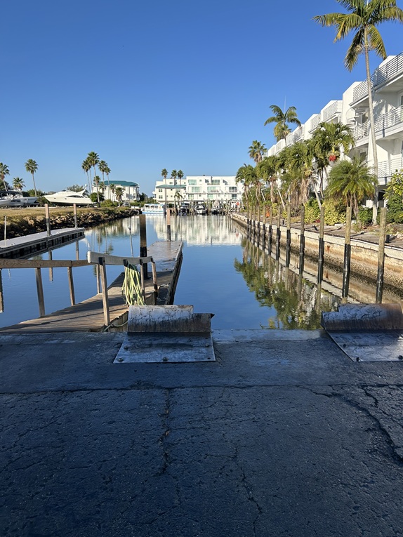
Finding Cape Haze Marina
Near Intracoastal Waterway Markers Red "8" and Green "9" there are
private channel markers into Cape Haze Marina on your port side as you are heading south.
After entering the Marina, turn right just after the first set of docks. Turn left at the
sea wall and proceed to the floating dock next to the rock sea wall. Note: If your
Class 4, 5, or 6 boat is too large or too difficult to get into the Marina, then it is not a
suitable Everglades Challenge boat. Violation of this rule results in a DQ.
- Cape Haze Entrance
Lat 26.875422°
Lon -82.314172°
- Cape Haze Dock
Lat 26.874206°
Lon -82.312763°
- CP1Beach001 - See SMALL BEACH LANDING BELOW
Lat 26.87348°
Lon 82.31439°
- CP1Beach002 - Trail Head to CP1 - See SMALL BEACH LANDING BELOW
Lat 26.87363°
Lon 82.31445°
SMALL BEACH LANDING - The beach landing is for Class 1, Class 2, Class 3, Hobie
AIs, and Hobie TIs only. All other boats must go into the Marina docks. Class 3
boats and Hobies MUST retract or take off their amas and akas. Also, if you will
be at CP1 longer than 30 minutes, you must move your boat up
to the grassy area at CP1. These rules are intentional filters.
The beach landing is located near marker Red 8. As you are heading south, turn left just
after passing Red 8 and you can't miss the beach landing. The landing and trail to CP1
are near an apartment building so BE QUIET when you land or launch.

Check-In and Beach Landing
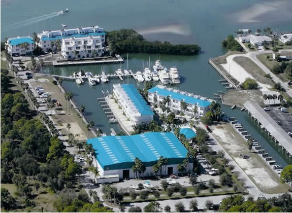
Cape Haze Marina Overview

IMPORTANT: Cape Haze Entrance Route
Slips shown in the Overview are GONE for now.
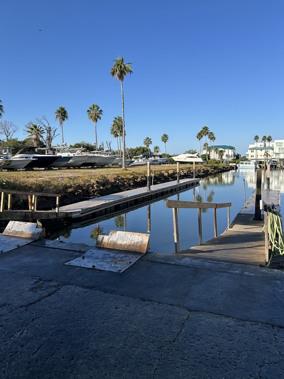
Floating Dock for Check-In
Checkpoint Captains will be set up in the grass area near the Marina docks. The Orange Lock Box containing
the check-in log will be in this area. The lock combination is 3 - 1 – 4. Please be sure the box is relocked
and secure after signing in.
Resupply is available at the Cape Haze Convenience Store, which is located at the end
of the Marina driveway. Their hours are 6am-7pm on Saturdays and 7am-5pm on Sundays.
There are also grocery stores within a couple of miles from the Marina. Fresh hose water
is available at the Marina, but you might want to filter for taste. Bottled water, sodas,
and snacks are available at the bait shop during Marina business hours.
Restrooms are available in the Marina store. See a check-point captain for access afterhours.
Camping is not permitted at CP1 except those finishing the Ultra Marathon or in an
emergency situation.
Vehicle parking is available in the lot behind the dry boat storage building. There
is also trailer parking for a fee. Please contact the Marina to make arrangements for
trailer parking.
|
|
ALL Events - Must Read, Understand, and Agree:
Warning
Rules
Special Launch Rules
Boat Classes
Reefing Rules
Required Equipment
SPOT Setup and Usage
inReach Setup
WaterTribe Entrance Requirements
WaterTribe Skill Assessments
How to Setup A Lifejacket
Packing Lite
Packing for Seaworthiness
|