WaterTribeTM BlackBeard Challenge (BBC)
Overview
The mystery of Blackbeard: Edward Teach or Edward Beard, may have been born in Charleston,
SC, or may have arrived in the new country with a colony of Swiss/German/English
refugees who founded New Bern. Blackbeard was an educated ocean-going sailor. He
was a pirate for about 2 years. He also frequented Charleston and Beaufort, may
have had family in Philadelphia, and eventually had a home on Bay Street in Bath,
NC, on the Pamlico River --reached via Ocracoke Inlet. Having strategically grounded
"Queen Anne's Revenge", he was 28 years old, was retired from pirating, and was
sailing a sloop "Adventure" with minimal crew when he was killed on 22 November
1718 in a naval battle at Ocracoke Inlet. His biographical facts are sparse. Bias
and distortions make most stories about him suspect. Were the cannon fuse wicks
he lit in his beard intended to terrorize? or... to keep mosquitos away? Ask the
members of the "Blackbeard Sailing Club" (a yacht club and marina in New Bern) what
they think.
Blackbeard is gone, but the awesomeness of Pamilco Sound continues to impress, and
sometimes terrorize, coastal sailors today.
The next WaterTribe BlackBeard Challenge is
Saturday, June 6, 2026. The BlackBeard
Challenge is roughly 300 miles long. It starts a few days before the NCC event but
both events finish at the same time. Be sure to check the schedule for the correct
event! There is a mandatory equipment inspection and captains meeting the day before
on Friday, June 5, 2026. Refer
to the schedule for time/date specifics.
Completion of a BlackBeard Challenge within the last Ultimate Florida cycle satsifies the entrance requirement for the Ultimate Florida Challenge. For example, completing BBC2021 allows entrance into UF2022.
Cost is $495.00
for the captain and $495.00 for
a crew member if any.
Billing starts Wednesday, April 1, 2026.
Registration ends Thursday, April 30, 2026 at noon.
Payment deadline is Thursday, April 30, 2026 at noon.
No refunds after the payment deadline.
Due to the exteme commitment for this challenge late registration and/or late payments will not be allowed. We recommend that you commit to this challenge early so you have
plenty of time for planning, training, and preparation. Pay early in the payment
cycle. You can get a full refund up until Thursday, April 30, 2026 at noon.
No refunds after that date and time.
All WaterTribe events are dangerous events as defined by law and common sense. You
are responsible for your own safety. You must read and understand
the WaterTribe
Rules and Warnings
before you register for this event. Although the warnings read
specific to Florida, they all apply to the NC environment and must be read and understood
for this event.
The BBC distance is roughly 300 miles depending on your course selection. The course for this challenge has
been changed a bit from last year. We are going back to our original starting location on Cedar Island.
But due to lessons learned in previous years we are going to provide very flexible launching options as
follows:
-
Plan A:
Launch from the north facing beach near the ferry landing. This is very weather dependant
and is up to you. It is OK to get all setup on inspection day and then change your mind on
launch day when you see huge waves crashing on the beach. You cannot launch if a ferry is coming in or going out.
-
Plan B:
Launch from the boat ramp near the ferry landing. You will have to wait your turn just like any other boat ramp. You cannot launch if a ferry is coming in or going out.
You must have a boat that could
launch off the beach.
-
Plan C:
Launch from any public boat ramp on the highway leading into Cedar Island. You still have to have a boat tha could
launch off the beach.
Special Note: We may use starting times based on your actual launch. Hit your OK Button or Message as you begin
launching off the beach or boat ramp.
This will turn out to be a lot less complicated than it sounds and we will be able to adapt to a wide range of
weather conditions. If the weather is good and forecasted to be good for the launch, Plan A is preferred.
But no matter what, you can choose any of the three options. Please let race management know if you are
going to use Plan B or Plan C.
The course proceeds in a roughly counter-clockwise manor as shown in the tracking map.
We have also loosened up our course requirements. You must proceed to each checkpoint in
the correct order, but you can choose any course you want depending on the weather, your
boat, and your prudent selection. For example, from the Start to CP1 you can go inside or
outside. It's up to you. Then from CP1 to CP2 you can choose inside or outside again.
It's your choice.
From CP2 to CP3 again you have a choice. Take Clubfoot Creek and the Hawlowe Canal or hit
your OK at CP2 and then go back up to the intercoastal.
The waypoints are shown as general guidelines for the course.
They are not intended for navigation.
We also have two preferred options for the finish. You can finish at the beach on the outside or go to the small boat ramp and dock on the inside. The third option is the boat ramp at the end of Ditch Path Road near the Islands Choice convenience store. Although the 3rd options is accepted, it is not preferred and should only be used to avoid dangerous weather.
There are restricted areas along the route. You must mark these areas on your charts and be well aware
of their location and rules. Some of these areas are used for bombing, shelling, and strafing practice.
Be sure to chart a course that leaves plenty of room for these areas.
There is an overall maximum time limit of approximately 7 days.
BBC2021 Tracking Map
The link above will take you to the tracking map which is the best way to view the course.
| Waypoint
|
Race
|
Location
|
Lat/Lon
|
| Start
|
BBC & NCC
|
Cedar Island
|
35.017600°
-76.311600° |
| CP1 - Virtual
|
BBC
|
Alligator River Marina |
35.905949°
-76.029933°
|
| CP2 - Virtual
|
BBC
& NCC |
Clubfoot Creek |
34.921700°
-76.759200°
|
| CP3
- Virtual |
BBC
& NCC
|
Beaufort City Docks |
34.715067°
-76.662567°
|
| Finish |
BBC & NCC |
Cedar Island Beach
or
Cedar Island Inside
or
Ramp at Ditch Path Rd |
35.017600°
-76.311600°
or
35.016100°
-76.315500°
or
35.004400°
-76.316700° |
| A virtual CP means that you hit your SPOT/inReach OK Message or Custom Message to checkin. There will not be a CP Captain on site at virtual CPs. |
Note: The table includes waypoints for both the BlackBeard Challenge (BBC) and
the North Carolina Challenge (NCC).
The BBC is run as an unsupported, expedition-style adventure races for kayaks, canoes
and small boats. Your safety and well being are completely up to you.
You should be an expert kayaker and/or sailor before you consider this challenge.
Although this event is not an open ocean race, the location is coastal, subject
to the same weather patterns and conditions one finds beyond the narrow barrier
islands and impacting the shallow sounds.
Unsupported means that there are no safety boats or support crews to help you during
the race. You are not allowed to have a support crew follow you or meet you during
the race. It is okay to have family or friends meet you at the official checkpoint,
but they cannot provide anything other than emotional support. See the official
WaterTribe Rules for more details.
Expedition-style means that you should carry the same type of equipment and supplies
that you would carry on a major expedition. Camping equipment, food, water, safety,
communication means, etc. is required. Please read the WaterTribe Challenge Equipment
List (in the Rules PDF), which details required equipment for a Challenge. For either
event, please choose your equipment needs carefully. Everyone must also carry all
safety equipment as specified by the Coast Guard, local regulations and common sense.
In addition, all boats in this challenge are also required to carry a SPOT or inReach device. Please read the instructions for Spot or inReach Setup
and Usage for WaterTribe events.
Although this is a race, many participants are more interested in cruising and adventure.
Whether you are a cruiser or racer is up to you; time allows for both. Just getting
to the starting line is a major accomplishment, and many starters will not finish.
A banquet lunch and award ceremony for the BBC will take place Saturday beginning at about 10:30
at the new facilites on Cedar Island.
Accommodations
You basically have three choices for accommodations during these NC events:
- The motel on Cedar Island is now open. Be sure and mention you are with WaterTribe.
- The campground has been upgraded and is available for tents or RVs. Be sure and mention you are with WaterTribe.
- Here is the link for the motel and campground: Cedar Island Resort
and phone (252) 515-0201.
- Or get a motel room, Bed-And-Breakfast or campsite at any location within driving distance. There are several from Beaufort to
Cedar Island.
Weather
Weather and sea conditions for Oriental, Neuse River, and Pamlico Sound can be found in this great web site:
Town Dock
Look in the INSIDE TOWNDOCK section on the right side of the home page for weather links, ferry schedules, etc.
|
Schedule
Registration, Waivers, Float Plans -
Friday, June 5, 2026
Is Mandatory .
Gear Inspection -
Friday, June 5, 2026
Is Mandatory .
Start - Saturday, June 6, 2026
Finish - Saturday, June 13, 2026
| Locations |
Times |
Notes |
Captains Meeting
Gear Inspection
|
Cedar Island
|
Registration & Paper Work
Friday 6/5. 10:00-15:00
Gear & Boat Inspection
Friday 10:00-15:00
Captains Meeting
Friday 15:00-17:00
|
Attendance Is Mandatory
|
|
Start:
|
Cedar Island |
Saturday 6/6
Assemble: 05:00-05:30
Roll Call: 05:30-05:45
Launch Window: 06:00 - 10:00
No Launching: 07:10 - 07:40
due to ferry
|
BBC Start
NOTE: Launch time may
change
due to ferry schedule.
There are alternate launch
sites depending on weather
and your choice.
|
|
CP1
|
Alligator River Marina |
Challenger Deadline
Monday 6/8 - 10:00 |
Virtual CP1 |
|
CP2
|
Clubfoot Creek Entrance |
Challenger Deadline
Wednesday 6/10 - 10:00 |
Virtual CP2 |
|
CP3
|
Beaufort City Docks |
Challenger Deadline
Thursday 6/11 - 10:00 |
Virtual CP3 |
|
Finish:
|
Cedar Island
|
Challenger Deadline
Saturday 6/13 - 09:00
|
Finish |
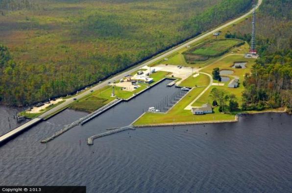
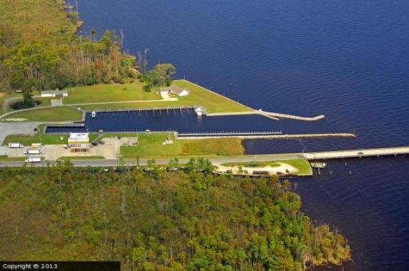
Start and Finish - Cedar Island, North Carolina
Both the BlackBeard Challenge (BBC) and the NC Challenge (NCC) start and finish at Cedar Island.
Please Note: Although these events start and finish at the same location,
the start dates are different. The finish dates are the same.
Inspection day for the BBC is Friday. Try to arrive early enough to get your registration and inspection. Try to finish setting up by 15:00.
There will be a captains meeting at 15:00. Attendance is mandatory. The meeting will be held at or near the Cedar Island resort. The exact location will be provided when your arrive for inspection and registration.
You have three starting options that are outlined in the Overview. Choose wisely according to the
weather and your boat.
The preferred finish is the beach next to the ferry landing and boat launch ramp on the outside and the boat ramp/docks on the inside.
An alternate finish is OK at the boat ramp at the end of Ditch Path Road. This should only be used if there are weather issues.
There will be an award ceremony and brunch at 10:30 on Saturday. The official deadline is Sunday at 09:00.
CP1 -
Alligator River Marina, North Carolina
CP1 is a virtual checkpoint. You must hit your OK or Custom button within about 1 mile of the lat/lon for this CP. You
do not have to enter the marina in order to checkin. Of course, you may enter the marina if you wish and pay their normal docking
or ramp fees. They do have a very good short order grill there that could make a stop very enjoyable. Also, note that you do not
have to go under the bridge either. Your OK or Custom button will be recognized within 1 mile of the checkpoint. I do recommend
that you hang out within that 1 mile until your OK or Custom light stops flashing.
CP1 is located at the immediate North West corner of the Alligator River bridge
off highway 64 at the mouth of the Alligator River and the Albemarle Sound. Depending
on your route, you will have reached this either by:
- Inside Route: Crossing The Pamlico River into the Pungo River, ICW connector ditch (20 mi with
cypress marsh on both sides) and into the Alligator River.
- Outside Route: Taking Pamlico Sound into Roanoke Sound then Albemarle Sound and into the mouth
of the Alligator River.
Your next leg to CP2 can also take any of the above routes.
CP1 is a refueling port for yachts on the ICW heading to or from wintering in Florida.
The CP contains a small boat ramp, docks, Shell gas station, convenience store,
and a short order grill. The boat ramp and parking area must be kept clear
at all times so clear the ramp as fast as possible. Larger boats may need to be assigned dock space.
The Boat Captain (you) will work this out with the marina.
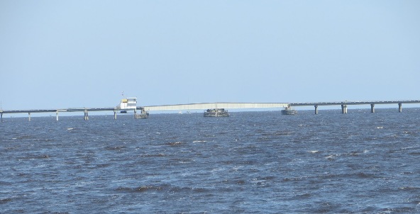
The Alligator River Bridge is a 2.8 mile long swing bridge with closed vertical
clearance of 14 ft at the center. This bridge will not open in high winds (35+ kts)
or reduced visibility (they are afraid cars won’t see the stop lights), there are
no set standards it is up to the bridge tenders discretion. The bridge opens on
demand VHF channel 13.
There is a large grassy field to camp, but you must get permission from the managers. If you are given permission
to camp, we ask all to be considerate of the owner Ms Wanda (who lives on the property) and her other clients
by being quiet at night.
CP1 is located along the Alligator National Wildlife Refuge, composed of 152,00
acres, 28 miles from north to south and 15 miles east to west and lying in North
Carolina’s Coastal Plane. It is bordered on the West by the Alligator River and
the Intracoastal Waterway, which is crossed by the 2.8 mile bridge on the North
by Albemarle Sound, on the coast by Croatan and Pamlico Sounds, and on the South
by Long Shoal River and incorporated farmland.
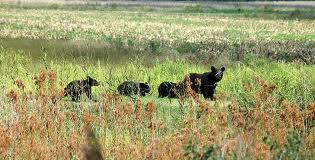
The refuge is one of the premier strongholds for American Black Bear on the Eastern
Seaboard. It also has concentrations of ducks, geese and swans. The wildlife diversity
includes wading ducks, shorebirds, American Woodcock, raptors, American Alligators,
White-tailed Deer, Raccoons, Cottontail rabbits, Bobwhite Quail, Northern river
Otters, Red Wolves, Red-cockaded Woodpeckers and neotropical migrants.
The refuge was established to preserve and protect the unique wetland habitat type
– the pocosin – and it’s associated wildlife species. Pocosin is a Native-American
word meaning "swamp-on-a-hill" and is characterized by poorly drained soils high
in organic materials.
Diversity of habitat types including high and low pocosin, bogs, fresh and brackish
water marshes, hardwood swamps, and Atlantic white cedar swamps. Plant species include
pitcher plants and sun dews, low bush cranberries, bays, Atlantic white cedar, pond
pine, gums, red maple, and a wide variety of herbaceous and shrub species common
to the East Coast.
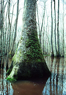
Nyssa Aquatica Tree in the Alligator River National Wildlife Refuge
Pamlico Sound, is the largest lagoon along the U.S. East Coast, 80 mi long and 15
to 30 miles wide. It is a body of water separated from the Atlantic Ocean by the
Outer Banks, a row of low, sandy barrier islands, including Cape Hatteras. The Neuse
and Pamlico rivers (the latter is the estuary of the Tar River) flow in from the
west. Pamlico Sound is linked on the north with Albemarle Sound through Roanoke
Sound and Croatan Sound. Core Sound is the narrow southern end.
Explorer Giovanni da Verrazzano mistook the sound for the Pacific Ocean. The sound
and its ocean inlets are noted for wide expanses of shallow water and occasional
shoaling, making the area hazardous for larger vessels. In addition, the shallow
waters are susceptible to wind and barometric pressure-driven tidal fluctuations.
This effect is amplified on the tributary rivers, where water levels can change
by as much as two feet in three hours when winds are aligned with the rivers'
axes and are blowing strongly.
Pamlico Sound is part of a large, interconnected network of lagoon estuaries. As
a whole it is the second largest estuary in the United States; (Chesapeake Bay is
the largest). Seven sounds making up the whole: Albemarle Sound, Currituck Sound,
Croatan Sound, Pamlico Sound, Bogue Sound, Core Sound, and Roanoke Sound.
Virtual CP2 On the Water Entrance to Clubfoot Creek
IMPORTANT: This is a virtual checkpoint on the water. That means nobody will be there to meet you.
You MUST hit your OK Button within 0.10 nautical miles. (Hint: Try to get within 0.05 nautical miles just for a
little wiggle room.)
The GPS location for this VCP2 is google.maps.LatLng(34.921700, -76.759200).
Remember the WaterTribe Rule: You determine your course from one checkpoint to another. That means that after hitting
your OK message for this VCP, you can decide to take the Harlowe Canal or backtrack a bit and take the Intercoastal. It's totally
up to you.
Virtual CP3 Kayak Landing and City Docks, Beaufort, North Carolina
Upon leaving the Harlow Canal into the Newport River towards Beaufort, you will
be entering an area of very busy boat traffic and possibly strong tidal currents.
Morehead City and Beaufort are sound side seaports situated on opposite banks of
the Newport River. Both are very busy commercial, recreational and fishing ports.
IMPORTANT: This is a virtual checkpoint. That means nobody will be there
to meet you. You MUST hit your OK Button when you land.
The GPS location for this VCP3 is google.maps.LatLng(34.715067, -76.662567).
Even with Covid-19 there will likely be stores and restaurants open if you have a mask.
The restaurants will probably be take out, but some might have outside seating. Adapt as
necessary. Also note that there is no overnight camping at this checkpoint nor across the
channel on the island. Plan ahead.
Beaufort, pronounced ''Bo-furt'' by locals, is the third oldest town in the state
with a rich maritime history. This quaint town was originally established in 1709
for its close proximity to the excellent deep-water inlet now called Beaufort Inlet.
Throughout history, Beaufort has always been an important seaport for whalers, fisherman,
merchants and even pirates. In fact, the notorious pirate Blackbeard and his crew
spent quite a bit of time in Beaufort, and their legacy still remains in the form
of the many legends and ghost stories that are still told.
In 1997, Beaufort was highlighted in national and international news as the wreckage
of what is presumed to be Blackbeard's flagship, Queen Anne's Revenge, was discovered
in 20 feet of water, two miles from Beaufort Inlet. Artifact recovery operations
were immediately able to identify—and in some cases retrieve—many pieces, including
the ship's bronze bell, cannons and deck guns. Some of these artifacts are already
touring the country or are on exhibit in Beaufort at the NC Maritime Museum.
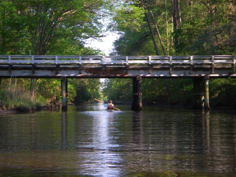
The Harlowe canal is the required route and is entered thru Clubfoot Creek off
the Neuse River, and is the old original Intracoastal Waterway (ICW), located west
of the current ICW, connecting the Neuse River with the Morehead City and Beaufort
waterfronts. Known locally as the Slave Canal because it was deepened to five or
six feet by slave labor, the Harlowe is one of the oldest canals in the United Sates,
originally created untold centuries ago by Indians who dragged their canoes across
the lowlands to the Neuse.
The canal is narrow but deep enough for most boats (but take care with the shallow twists and turns
entering and exiting the canal), with three bridges that will require the sailboats
to step their masts. Beautiful and tree-lined, the Western side of the canal is
part of the Croatan National Forest. There is some tidal influence on the southern
side and from wind effects on the Neuse.
Upon leaving the Harlow Canal into the Newport River towards Beaufort, you will
be entering an area of very busy boat traffic and possibly strong tidal currents.
Morehead City and Beaufort are sound side seaports situated on opposite banks of
the Newport River. Both are very busy commercial, recreational and fishing ports.
You’ll need to go under a car bridge exiting the Newport River and entering Beaufort.
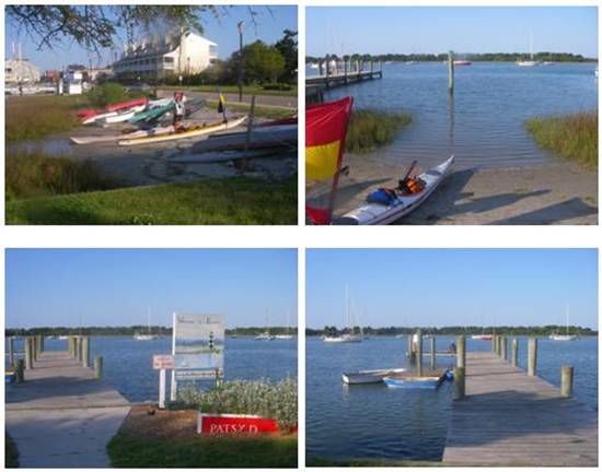
The NCC checkpoint (just a few hundred yards down the street from the NC Maritime
Museum) is located on the historic waterfront of Beaufort’s Taylors Creek at Graden Paul
Park, WP3. The park contains a small public canoe and kayak beach landing
and a small public dock for the larger boats. Sailboats coming into the dock must
come in on the starboard side as entering. There are no public facilities at the
park, however there are water spigots and hoses all around the nearby docks (walk
to your left up Front St), and a public restroom a few hundred yards left up Front
St (at the end of the marina), not to mention some nice (yet expensive) seafood
restaurants and tourist shops, if you’ve got the time :)
Physical Check-In Station
This is a virtual CP. There won't be anyone there to meet you. You cannot camp at this location.
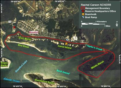
Opposite the checkpoint across from Taylor’s Creek, the string of small islands
(pictured below)—Carrot Island, Town Marsh, Bird Shoal and Horse Island—more than
three miles long and less than a mile wide—include the Rachel Carson Reserve, part
of the North Carolina Coastal Reserve & National Estuarine Research Reserve. Accessible
by boat only, visitors are allowed and there are even walking trails. But, NO CAMPING
is allowed and this is strictly enforced. As you pass by these islands, you are
likely to see the small herd of feral horses which roam the island, and many of
the 200 bird species which have been recorded there.
|
ALL Events - Must Read, Understand, and Agree:
Warning
Rules
Special Launch Rules
Boat Classes
Reefing Rules
Required Equipment
SPOT Setup and Usage
inReach Setup
WaterTribe Entrance Requirements
WaterTribe Skill Assessments
How to Setup A Lifejacket
Packing Lite
Packing for Seaworthiness
|