Everglades Challenge 2004
So much . . . Adventure
By Dawn Stewart (aka SandyBottom)
About six years ago,
transfixed in front of the TV when the Eco-Challenge Adventure
Races were televised, I was wishing I was doing that. I have always
felt well suited to
distance and endurance challenges, and had previously competed in
long distance
running and triathlons. Then, about 3 years ago, I happened upon the
WaterTribe
website and read about the Everglades Challenge. This, I thought,
would be perfect -a
custom made Eco Challenge based on paddling. A female, and over 50,
I was already
a skilled and active paddler, and had competed in a few long local
kayak races (I
thought 40 miles was long then), and loved kayak/camping
expeditions. Last
November, a WaterTriber nicknamed BlackSun offered his used
Everglades Challenge
marine charts for sale. The purchase was my commitment to do the 2004
Challenge.
The Everglades WaterTribe Challenge is an unsupported, expedition
style adventure
race for kayaks, canoes, and small boats. The Challenge follows the
SW Florida
coastline from Fort Desoto in Tampa Bay to Key Largo, a distance of
roughly 300 miles,
with a time limit of 8 days. The WaterTribe website
www.WaterTribe.com
contains more
information on the Challenge, including a discussion forum, magazine
section
containing numerous articles on preparing for a Challenge, as well
as articles from
those who have completed previous challenges.
I began preparing by reading everything I could find about
distance paddle racing, and
by becoming a participant of the forum. I was given lots of advice,
particularly from
BlackSun and SlackJack, on the forum and by e-mail. WaterTribe uses
nicknames
called tribal names; my family helped name me SandyBottom. I trained
seriously;
despite the cold winter we had in N.C., following Chief's articles
'Get Fit for a Challenge'
and 'Finish a Challenge'. I paddled a minimum of 3 times a week,
increasing my
mileage until I was paddling ~ 70 mi/wk, including at least one long
night paddle. I was
already an active swimmer, biker, and run/walker, so had a good
fitness base.
Luck was on my side when I found another women, tribal name
TurtleWoman (TW),
living near the coast of N.C. who had entered the EC last year, and
was planning on
attempting it again. It turned out that we would be the only 2 women
registered in solo
kayaks and the 2nd and 3rd solo women ever to finish a challenge. As
is often
recommended, we decided to form an ad hoc team for mutual support
and company
during the long hours of paddling. In WaterTribe, an ad hoc team
requires each
member to be totally self sufficient, carry all required gear, and
be able to complete the
event solo. Ad hoc teams are common, and are sometimes formed even
just for a day
or night. Unfortunately, prior to the EC, TW and I only managed to
get together on one
weekend to meet and paddle together. As we would experience more
than once during
the challenge, we spent that weekend paddling in the Neuse River at
Cedar Island, in
small craft advisories with winds 15-25 mph and fairly large seas.
We were quite
convinced we were going to be up to the task.
Our Challenge actually began 2 days prior to the event. While
driving down to Florida,
we realized that we would not make the campground at Ft. Desoto
before closing, so
we had to "stealth" camp in an uninhabited neighborhood the first
night. At Ft. Desoto
we ended up camping in the front seat of TW's car the night before
the race, because
no campsites were available. Needless to say, we were a bit sleep
deprived at the
starting line on Sunday morning. This is not something I would
recommend, but it
probably had me starting out in enough of a stupor as to tame any
jitters or
apprehensions.
Friday
|
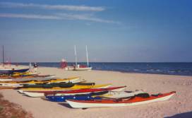
Ready for Launching |
Friday was a very exciting day at Ft. Desoto. I was finally
meeting Chief (the founder
and organizer of WaterTribe), and so many of the Challengers whom I
had come to
know and look up to on the Discussion Forum. Friday was also the day
I first
understood what a 'shipping channel' really was. Previously, I had
always chosen to
paddle in more remote areas (including a month long expedition in
Newfoundland last
year) purposefully to stay far away from boats. But here, there were
not just boats, but
ships - huge ships. Even the yachts I would continually see on the
Intra-coastal
Waterway throughout portions of the Challenge were larger than any
boats I was used
to paddling around.
Friday was also check-in day, equipment inspection (there are
very strict rules regarding
required equipment, including VHF radios and EPIRBS), and the
Captain's meeting.
There were 26 boats (kayaks, canoes, sailboats) signed up for the
EC: 12 of them were
single kayaks. Another 21 boats were planning to do the Ultra
Marathon (UM), which
was a 2 day, 67 mile event; way too short for my delusions of
grandeur. At the meeting,
Chief went over all the rules, provided information about the
checkpoints and deadlines,
emergency phone numbers, etc., then he proceeded to warn us about
the animal
hazards; bears, sharks, alligators, crocodiles, rattlesnakes,
cottonmouths, coral snakes,
sting rays, barracuda, spiders, bees, hornets, wasps, fire ants,
ticks, mosquitoes, poison
ivy and the poison Manchineel tree. Oh boy!
Saturday
Saturday morning started early, and in the dark. Everyone seemed
busy with last
minute boat packing, shuttling cars, and picture taking. It was a
beautiful site with so
many boats lined up for the start, as both the EC and the UM
challenges begin at the
same time. At 7AM the race began. All boats are required to start
above the high water
mark, and no help was allowed to drag your boat down to the water.
TW and I, and a
few others, still had another few minutes of packing before we were
ready to take off.
After all, what's a few minutes when you're about to embark on a
300-mile trip? Some
chose to wait for the melee to clear out and then enjoy a more
leisurely start. Others
took the idea of a race to heart, and sprinted with their boats to
the water. There was a
stiff headwind from the SE (in our faces), and a sandbar a few yards
out from the start
with small waves coming over. I remember thinking how embarrassing
it would be for
someone to tip over within the first few feet of the race and
wondering why is it so windy
so early in the day. With such a large fetch, the seas across Tampa
Bay were all white
capped, making it difficult work at the start. It turned out; this
was actually some of the
easy stuff, and just the beginning of the challenging conditions TW
and I would face
throughout the rest of the week of the Challenge.
It was slow going across Tampa Bay in the headwinds. I could see
a few boats ahead
of us, and a few behind, but wondered where most of the other boats
went. Were they
really going to 'race' for 300 miles? The crossing, luckily, was
without any ships in the
channel, but with its large fetch and wind generated swells (2-3')
was rough enough to
occasionally force us to pause, raft up, and pump out TW's open
cockpit.
It was from this slow beginning that TW and I would start to
discover differences and
similarities in our paddling styles and personalities. I have been
paddling for about 10
years, including 6 years teaching/guiding for Rock Rest Adventures,
and spending any
free time kayak surfing or expeditioning. I prefer the traditional
Greenland paddle, but
consider myself a modern paddler, certainly enjoying all the latest
high tech gear. TW
thought of me as a techie or gear head. Quite proud not to be
considered a techie, her
stated preference was for navigation by compass and chart rather
than GPS and chart.
TW had previously spent 10 years as an Outward Bound Guide all
around the country,
also had expedition experience, and was in the process of starting
up her own kayak
tour-guiding company.
I had trained religiously for the past few months regardless of
the cold, paddling long
distances locally (Chapel Hill, N.C.) on a nearby large lake, with
occasional weekends
at my favorite playground at Bogue Inlet in Swansboro. Winter
coastal conditions kept
TW out of the water through much of the winter, forcing her to spend
training time in the
gym on a rower. TW was paddling a beautiful brand new Kevlar kayak,
a Seda Glider
that had just been delivered to her the day before we left --a boat
she had not paddled
previously. I had my beloved NDK Explorer, which I felt very
proficient in, in both flat
water and big seas and surf. I prefer kayaks with a lower deck and
good thigh contact
in order to edge and maneuver without need for a rudder. TW
preferred the comfort of
a boat with a higher deck and larger cockpit. Whereas edge turns in
my boat require
the use of a tight fitting spray skirt, TW prefers to paddle with a
rudder and without a
spray skirt, thus avoiding heat and constriction whenever possible.
Despite our differences, there were similarities as well, which
is what enabled our ad
hoc team collaboration to work. We are both incredibly goal driven,
strong willed, and
physically strong. We were determined to finish this race no matter
what, helped by the
fact that both of us have a very high tolerance for discomfort. Our
mental attitude and
desire, more than anything else, were the key ingredients in the
recipe for our success.
And there were other areas where we complimented each other. TW had
dropped out
of the race last year after 180 miles; serious chaffing resulted in
some open wounds that
became septic. For most of that distance, she had paddled alone, and
said she had
found it quite stressful. Paddling solo in the dark in unfamiliar
waters was my biggest
concern as well. Together we provided companionship and a safety net
that made for a
much more relaxing and enjoyable trip. To our ad hoc team, TW
brought previous
WaterTribe experience, familiarity with the Everglades area (a
definite advantage I think
the Florida paddlers have over other competitors), having run many
guided trips out of
there years earlier. I brought the techie waterproof charts and GPS
system
preprogrammed from Blue Chart software. In the end, despite some
differences and
the occasional frustrations team members have, I believe our teaming
up helped to
assure our eventual success.
After crossing Tampa bay we stopped to stretch and bail at a foot
of the bridge at the
head of Anna Maria Sound. Etchemin and Porky in a Kruger SeaWind
were doing the
same, and RubberDucky pulled up in his Folbot. As it turned out, we
would count
ourselves lucky to see RubberDucky again a few times this day and
night. I recall
Etchemin and Porky commented on how tired they were already, and on
the amount
of paddling they had already had to do. I found this quite
interesting, as we'd only
paddled about 10 of the 300 miles. Registered as a Class 3 boat, and
with these
headwinds, this was not the sailing weather they wanted; this would
change in favor of
the sail-equipped boats later in the week.
I was beginning to realize that our little group was definitely
trailing up the rear. TW had
preached a mantra all the way up on the drive, 'pace is the key,
it's all about pace.' I
have to admit that I was already getting a bit worried that we might
need to be picking
up the pace a little. We were paddling a speed much lower than I had
expected and
trained for. TW would continue to repeat her mantra and I just
figured if I had to paddle
16 hours a day as Chief had said to expect, this was certainly going
to be a pace that I
could handle, plus more (a good thing).
By 5pm we had only paddled about 25 miles. I was again silently
worrying about the
pace and the length of our rest stops. (Oh, did I mention I'm a
worrier and TW has no
worries?) I didn't think we could ever make the finish at this rate,
and maybe not even
make the first checkpoint. I was also worrying a bit about TW, as
she was not her usual
talkative self. Something was clearly not right; she was not feeling
well. Neither of us
had done a good job that day of eating and keeping up our energy,
more critical for TW
who has low blood sugar and was definitely out of her zone. This was
an easy fix and a
mistake we would not make again. During the rest of the week, we
would refuel on a
regular schedule, and, in fact did such a good job from then on as
to not have lost any
weight throughout the Challenge.
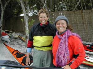
|
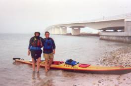
SandyBottom and TurtleWoman |
To prepare for nighttime paddling, we stopped at the bridge at
the end of Sarasota Bay,
put warmer clothes on, and found our flashlights and boat lights.
While there, we met
two older women who were walking on the bridge and came down to talk
to us. They
were so excited to hear about our adventure, "would have loved to do
something like
this when they were younger" and promised to read about us on the
WaterTribe
web site. Feeling a great boost in morale and hoping to make up for
lost time, we
paddled onward. It was at this point that I realized, though also
refusing to believe,
there was a slight hint of fog starting to come in from the ocean.
Within the hour, we were in a thick fog with little to no
visibility. I was beginning to think
I was jinxed and back in Newfoundland. I had spent a month paddling
the SW coast of
Newfoundland with 2 friends the past July, and had spent 80% of the
trip paddling in a
blind fog. Entering Roberts Bay, we again ran into RubberDucky not
far from the
bridge. He was looking for a place to pull over in the fog for a
brief stop. We chose not
to wait for him; wrongly assuming that once we got paddling we would
be so much
faster than he in his 15' Folbot. (He showed us up the next day).
The next 15 foggy miles took us 7 hours. It was impossible to see
the channel markers,
and even those with lights often only added confusion. We were
completely reliant on
navigating with my new GPS with mapping. I had downloaded way points
and charts of
the area from my PC, but I still had not taken the time to properly
read the instruction
manual, thinking maybe I would do so on the drive down to Tampa Bay
(yeah right).
TW was a chart and compass paddler, completely unfamiliar with GPS
navigation. We
were actually doing fairly well (I think), until at one point in
Little Sarasota Bay, I thought
I saw a light marker and started following it, only to discover too
late, when we paddled
right up an Oyster Bed, that the fog must have lifted for a few
minutes and I had been
following a porch light. Often the boat channels were very narrow,
and once off track,
the water became very shallow, even too shallow for a kayak at
times. TW's new boat
was not very happy with the oyster beds, no need to comment on how
TW felt. We
were now off the channel, not sure by how much (by the end of our
week, I did manage
to learn these things), and we seemed to be surrounded by Oyster
beds every which
way we turned. Finally, out in the fog we saw a light and a voice
asking, "Are you
WaterTribe?" Again, our old friend RubberDucky (RD); his GPS
batteries had just given
up, but he was still in the channel. RD, TW, and I paddled the
remaining few hours that
night, staying in the channel, aiming for Snake Island, our now
newly planned overnight
destination.
Our first day had taken 19 hours when we reached Snake Island at
about 2AM. There
were a few other kayaks on the beach, and a telltale WaterTribe
style hammock tent.
When I called home, my husband Paul, also known as 'DanceswithSandyBottom,'
told
me that indeed a few other Challengers had come in an hour or so
earlier and were also
camping on the island. These turned out to be Chief, Manitou
Cruiser, and Wayfarer. I
later discovered that Bear was also camped out on the other side and
didn't see any of
us. I was starting to feel better knowing we were among other
challengers, though
mostly sailors. They would make up this time more quickly than us in
the end.
Sunday
All headed out before our 7:45AM departure. Chief and ManitouCruiser went out the
inlet into the Gulf to catch a breeze. RubberDucky started down the
Venice Channel
around the airport, which was also our planned route. For the rest
of the day towards
Grande Tours, I continued to expect we would catch up and overtake RubberDucky, but
we never did. He later told me with a big grin that he had paddled
all day without
stopping, as having registered for the Ultra Marathon; he did not
want to be overtaken
by us so-called faster challengers.
TW and I continued paddling through Venice Channel and up Lemon
Bay. We stopped
for lunch on a small beach in the Bay in front of one of the large
waterfront houses.
Large wakes from boats in the channel created havoc on our landing
spot, and when
TW picked up her boat to move it further onto the shore, it
accidentally slipped and the
full weight of the bow landed on the top of her foot. There was
immediate swelling and
bruising, and we feared something was broken. Deciding she didn't
need her foot to
paddle, we planned not to let race officials know for fear they
would take her out of the
race. As it turned out, her foot was not broken, and although badly
bruised and painful,
felt better each day.
Continuing, we ran into Bear lounging and sailing in his Easy
Rider about 30 minutes
from Checkpoint 1 at Grande Tours. We arrived together about 5PM (25
miles in 9 hrs).
This pace of about 2.8mph would turn out to be typical for us with
the rest/eating stops
we made along the way. I was again worrying about our pace. If TurtleWoman was
aptly named, I was just hoped we would enjoy the same ending as the
classic fable of
the tortoise and the hare. TW was a firm believer in finding a
comfortable pace, and
then… keep moving forward. Weeks later when reviewing the GPS data,
it became
clear that our paddling speed was actually quite reasonable, but it
was our rest breaks
that had a huge impact on our overall average pace.
|
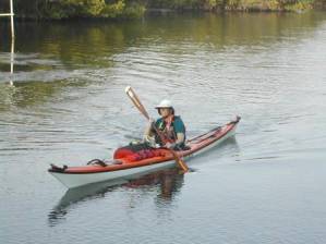
SandyBottom Arriviing CP1 |
We rested and showered at Checkpoint 1. The festivities of the
Ultra Marathon Finish
were pretty much over and there were only a few competitors hanging
around. Most of
the challengers had left for the second checkpoint during the day.
Chief and ManitouCruiser were still there eating and getting ready to sail out for
their non-stop exciting
adventure to Chokoloskee (that is their story to tell). Pelican was
the last remaining
Challenger yet to come in. Later, he told me he had miscalculated
and taken the
outside route at Tampa Bay where the headwinds made forward movement
in his sit-on-top peddle/paddle/sail kayak almost impossible.
Weather reports were now predicting a cold front moving in around
midnight, bringing a
drop in temperature, high winds, and small craft advisories. We ate,
showered, and left
by sundown, planning to paddle across Charlotte Harbor at least to
Cayo Costa before
the front moved in. This was a beautiful evening paddle. The stars
were out and there
was a slow wind at our backs. There was also the anxious feeling
about the front, and
some apprehension after hearing a few horror stories about Boca
Grande Inlet in bad
weather. Eventually, the winds slowly picked up behind us such that
Chief and MC
sailed past us becoming a speck in the moonlit horizon. We continued
to paddle up the
inside coast of Cayo Costa, keeping an eye out for any cloud
formations that would
indicate the front. The only real excitement that night occurred
about 1:30AM when I
somehow awakened a sleeping manatee that literally jumped out of the
water not a foot
from the stern of my boat. TW saw the manatee as it came out of the
water. I only
heard the explosion and felt the large resulting wave. Who would
have thought those
big animals could jump? This scared all the energy I had left right
out of me and we
decided it was time to find a campsite. The full brunt of the front
hadn't arrived yet, and
we had just made better distance than hoped for (another 15 miles).
TW remembered a
nice sandy point just ahead. We stopped at 2:30AM on the southern
tip of Cayo Costa
Island, about 8 miles N of Sanibel Island; an 18-hour day.
Monday
We made a late start at about 10AM. The front had arrived during
the early morning
and we woke to strong NNE winds. These winds would help push us down
Pine Island
Sound, past Pine Island, Sanibel Island, and Ft. Myers. We spent the
day pretty much
hugging the channel, directly down the middle of the Bay, hoping to
lesson the miles.
The Bay had been total white caps throughout, and was quite an
exciting ride. We
arrived at Sanibel Bridge at 5PM and assessed the open waters of the
Gulf beyond it.
NOAA was reporting small craft advisories though the night, winds
20-25 mph, surf 4-6ft
and seas 8-12 ft. From the bridge, things didn't look too bad,
certainly not worse than
we had endured, and we figured conditions would remain that way for
a while. We
couldn't camp where we were, so decided to continue on, staying
close to shore in the
event we needed to get off the water, albeit with a surf landing.
Leaving the bridge was
actually quite a challenge. It required a surf launch into 2 ft
breakers with a sharp turn
into beam seas, and then another sharp turn into following seas and
under the bridge
where we had a mess of reflecting waves coming at us from all
angles. We were
crossing under the lower road bridge (rather than the draw bridge),
and with many so
many large cement pilings only about 8ft apart, the water was as
confused as anything
I'd been in before.
Once in the Gulf, we quickly noted that the sea swells were a bit
bigger, but there was
no real surf on shore. We still had a couple hours of daylight left
and in daylight, the
ride was actually fun, with swells only in the 4-6 ft range,
certainly not rougher than
either of us had paddled in many times before. However, this became
very different in
the dark. As it started to get darker, we opted to stay closer to
shore. Winds were
slowly picking up, and the swells were getting much larger. We were
about to cross Big
Carlos Pass just after sunset. Just at the very last bit of
twilight, we could see what
appeared to be heavy surf a few hundred yards ahead of us. Sure
enough, there were
shoalings and big surf all along this pass, the tide was ripping. We
yelled to each other
to head out to deeper water fast and still ended up hitting the end
of the shoals, bracing
through breaking waves well over our heads, 4-6 ft high, and in
total darkness (the
moon would not rise for hours). Not the largest surf I had been in,
but in the dark,
certainly the most frightening. Luckily, since we had already
started to turn outward,
nothing hit us directly in a broached position, with good bracing
and forward movement,
we managed to work through the surf to deeper water. More luckily,
TW was wearing
her spray skirt, knowing surf landing to camp would be likely.
We eventually paddled out a little more than a mile and a half
offshore, but we were
very wet and cold and knew our night was over. We would have to find
a landing.
Once on the other side of the pass, the shoreline appeared to be
completely
undeveloped. We couldn't see it very well, as there were no lights
at all. We figured
this was good and could mean a possible campsite. Up until this
time, the beach was
full of condos and hotels with lots of beach partying going on with
the start of college
spring break. Very apprehensively, in the dark, we slowly turned to
shore, hoping for
the best. Not knowing exactly how big the surf would be, but
assuming a surf landing
would be required, we discussed various plans, including swimming in
with the boats if
needed, as we knew the tide was incoming. I didn't ask TW if she
thought she could roll
her new boat, but figured her large cockpit and nylon spray-skirt
would make that
difficult anyway, so I just hoped for the best. Locally, I have a
small reputation for
rolling, and can do about 13 different Greenland style rolls, and
can successfully re-enter and roll my boat in surf. No one is 100% in surf conditions,
and in the dark who
knows. We paddled close together very slowly, both wondering on the
sudden
quietness. Amazingly, we looked over at each other and realized we
had already
landed in sand, with barely a ripple. Ahead of us was a small tidal
pool. We had landed
on the back side of a small sandbar, at slack tide. In front of us
was a sign for 'Lovers
Key State Park', and a beautiful site for day camping. Though no
overnight camping is
allowed, we knew we would be gone before the park opened in the
morning. I later
heard that Pelican had also camped here the same night. SharkStu was
also reported
to be somewhere in the area, and another group got off the water
around Gordon's
Pass, our original destination for the night.
It took 2 hours to set up camp, dry off, and warm up (which never
really happened). It
was reported to be 42 degrees Fahrenheit. I finally phoned home
about 10PM, still
quite excited over what had passed. Evidently, Paul had been quite
worried. He knew
the weather reports, and had been reading the worried posts of
others on the
WaterTribe Discussion Forum that indicated that many other
challengers who were still
in our area had gotten off the water before dark because of the bad
conditions. All he
had known was that we were still out there. I wished I had called
him earlier when we
landed. In the end, this was one of our short days, only 10 hours,
and we were still
about 54 miles from Checkpoint 2 at Chokoloskee.
Tuesday
We pushed off about 8AM, with conditions quite a bit milder,
still a NNE wind at our
back, but one that would help us. The sun was out and it was much
warmer. Weather
reports were calling for another front to move in later that day,
but we thought we might
be off the Gulf and into a channel of the intra-coastal waterway (ICW)
before that one
came in. The morning and early afternoon were very pleasant, with
ocean conditions
more like I am used to; interestingly though, not the flat
conditions I had heard I could
expect in the Gulf. There were lots of dolphins, and a beautiful
small loggerhead turtle
who came to pay each of us a visit, coming up out of the water only
a foot away from
TW's boat, then mine. She looked us both in the eye, and opened her
mouth as if to
smile. We decided to take this as a good omen for the rest of our
journey, as the turtle
has special significance to TW, with her Cherokee heritage.
Throughout the day, the scenery changed constantly, from
high-density condo/hotels to
beachfront acreage with unbelievably massive beach houses. About an
hour before
arriving at Gordon's Pass, we felt the next front move in. The
temperatures dropped
again very quickly and the winds again shifted. We were glad to be
going inside, and
had lucked out with the tide through this inlet.
There was still another 13-mile intra-coastal route before
reaching Marco Island and Big
Marco Pass, where we thought we could cut off some distance by not
going around
Marco. In this ICW, we saw a couple of manatees, one whose head was
completely out
of the water. This route would take us inside to Big Marco Pass; we
would paddle
across the Pass and head inward towards 10,000 Islands. We had hoped
we could
make Indian Key, assess the tides and possibly camp there and come
into CP2 early
the next morning (the cutoff deadline was nearing at 10AM the next
day). This was not
to be. Once we reached Big Marco Pass, the winds were really up
again, 25-30 mph,
and the temperatures had dropped below 50 (lower with the
wind-chill). We were both
feeling very cold again. The tide was incoming and the front was
causing very rough
conditions at the inlet. We decided to pull off on a sandbar just
inside of the pass, wait
for the tide to slacken, warm up and dress for the night, then cross
the pass. Two hours
later, out of the wind and in our sleeping bags, we were both still
shivering and fighting
off near hypothermic effects of the night before. It was clear we
would need to put up
the tent and get warm, and likely not be able to continue paddling
this night. It was only
6:30 PM; we had only managed 9 hours. We weren't going to make the
cutoff. I called
Paul and explained the situation, asking him to send in our
location, and request a
weather hold for us. This was within the WT rules, as small craft
advisories had been
issued for both the night before and this night, and we had been
forced off water both
nights due to these conditions.
Wednesday
Up at 3AM, with windy but manageable conditions, we were on the
water by 3:45. We
needed to paddle our butts off, still not knowing if we had been
granted the weather
hold. Not that it mattered; we had already decided that regardless,
the destination was
Key Largo. We knew we could make Key Largo by Sunday noon, in or out
of the
Challenge. And there was little reason not to be given the weather
hold.
The morning paddle was hard, winds were very gusty, and seas were
now quartering.
We stopped at a large key for a short break, assessed the tides,
which were in our
favor, called race management and left a message reporting our
estimated time of
arrival at CP2, and continued our paddle. It was now 10AM which was
the checkpoint
cutoff. We paddled straight into the Ranger Station at 2PM to get
our camp permit in
the Everglades (not willing to take a chance of being disqualified
later), made CP2 at
Chokoloskee at 3PM.
What a wonderful site, and a total morale boost to see SaltyFrog
(the race manager)
there waving his hands and cheering us on. The weather hold was not
a problem and
easily justified, but we would have to make the time up. There was
another 65 miles to
paddle by Friday 10AM. We called home, filled up our water bottles, had
some ice cream
at the small store across the street, and left for Pavilion Key by
5PM. Our plan was to
paddle the 10 miles there, camp the night, then paddle the remaining
60 miles non-stop
the next day and night to Flamingo. We landed on Pavilion Key in the
dark at low tide,
ending up struggling with dragging boats for at least an hour and
totally exhausting
ourselves. The good news was we would leave with a higher tide in
the morning,
helping to get the boats off the key. Also good was that I was able
to fix my skeg pull
which I had broken launching from Chokoloskee. Adept at paddling
without skeg or
rudder, I was worried that it would be very uncomfortable without my
skeg given the
winds we had been experiencing and the distances left to travel in a
loaded boat.
Thursday
We left Pavilion Key at 8am. I am a very early morning person,
and would have
preferred leaving earlier most mornings, and then ending earlier
most evenings.
However, I seemed to manage the late nights easily with a partner,
and it seemed to
me, easier than TW might have the earlier mornings, so this probably
turned out to be a
good team compromise. Again a very windy day, but NW winds were at
our backs and
rough seas pushed us along quite well for the 30 miles down the
coast towards Shark
River. This is a beautiful area in the Everglades Park. The sun was
out and warm, and
the beaches on these older keys off the gulf are beautiful. They
differ from the younger
Mangrove Keys, in having much more mature and diverse vegetation.
It was off Pavilion Key that we spotted quite a few sharks, some
seemingly very large.
At one point about 50 yards off, there were a number sharks that we
could only imagine
were in a feeding frenzy, given the maelstrom that was going on.
During the day we stopped for only one 30-minute break on a key,
and then stopped for
dinner about 5PM right outside the entrance to Shark River. There we
rested and
waited about 2 hours for the tide to slack. Leaving in total
darkness, following the GPS,
we paddled into the river. After about 3 hours of paddling, we
hadn't made as much
distance as we should have. TW was the one to finally realize that
we had stopped
moving forward. We likely had just spent over an hour in a small
channel just fighting
the tide and hadn't even realized it. We had misjudged the tidal
offset.
Interestingly, she had just earlier told me a story about one of
her Outward Bound trips
where they missed the tide and had to pull up alongside a mangrove
island, hanging
onto the bank waiting for the tide to change. This was all we could
do. Ferrying over to
a mangrove, we grabbed its roots and hung on for the next 2 hours in
the dark. The
whole time, there were a couple of dolphins less then a few yards
away entertaining us,
and making an absolute racquet.
We resumed paddling at midnight, still with about 20 miles to go.
Trying to follow the
GPS carefully, we made our way to Oyster Bay and then into White
Water Bay, which
were huge ––very roughly 10 miles long and 5 miles wide. Even in the
dark I could feel
its size. Chief had told us that once in the Bay it would be easy to
navigate all the way
to Tarpon Creek following the Wilderness Waterway markers. We
followed a couple,
and then lost them totally, never to find them again. It was
overcast, very dark, and
quite breezy. We paddled down the middle of the Bay looking for
markers. There were
no small islands to stop and rest on, nor would there be a place to
camp. By 3AM,
staying awake was difficult and in fact, I'm not sure how awake we
actually were. Every
once in a while TW would take a few seconds of catnap, her head
would drop back, and
then she would wake up and jerk her head up. At one point, she
looked at me in all
seriousness and declared "don't worry, I can paddle and sleep at the
same time." I'm
pretty sure we were moving forward, but not very fast. Looking later
at the GPS data,
there were times that night where we were barely paddling 1 mph,
weaving all over the
place, never managing to stay on a course. But, in true WaterTribe
tradition, we
continued to move forward.
Friday
About 5AM, the winds picked up and it became very cloudy, looking
like it was going to
storm. For some reason, neither of our VHF radios were able to pick
up a weather
report, and we hadn't seen a channel marker in hours. The GPS
clearly showed we
were in the Bay and seemingly on our way to CP3, but not on the
course we should
have been. We could see the Flamingo tower lights in the distance
and figured we were
probably 6-8 miles away, but there were many mangrove islands in our
way, which
shouldn't have been. We finally stopped on one, found a solid
footing, and decided to
wait till sunrise to access if a storm was indeed coming in, and
hopefully see where we
were. This was a very small island, maybe 5 yards in diameter, with
only one section
that appeared solid, but with no open areas. We wrapped our
Thermarests around us,
dove into the tree roots, managed to get our butts on the ground but
with legs and arms
sticking up, with a tent fly rigged as a temporary tarp if it
rained. Cold again, we were
still constantly fighting the after-effects of Monday night's
adventure. I remarked that I
felt like we were in Wilderness Survival Training School. I also
remember closing my
eyes and absurdly thinking how very comfortable I was. We were
exhausted. Except
for the 30-minute break on the Gulf and the two-hour break near
Shark River, we had
been in our boats for 21 hours. We had 5 hours to make the
Checkpoint, something
close to 8 miles, and we were feeling a little disoriented, and
needing rest.
We slept solidly for 90 minutes. Cloudy and breezy, there was no
impending storm, and
we were back on the water by 7AM. We took some time studying the
charts and the
surroundings, trying to make sense of the GPS routing. A few false
starts forced us to
paddle around a couple of mangrove islands 'which just shouldn't
have been there,' and
we finally found our route (still no markers) and made our way. As
we were entering
Tarpon Creek, a boat with 2 Rangers stopped and asked if we were
part of the
WaterTribe and if we knew if there were still others behind us. We
told them our names
and asked them to let the others know we were on our way, expecting
to make cutoff.
We landed at the boat dock at 9:45AM, 15 minutes before the 10AM
deadline, and so
thrilled to have made it! I didn't even think to look out for the
large crocodile that chief
had warned us to look out for, as he has made his home on the dock
for a few years.
SaltyFrog was there and filled us in on how everyone else was doing.
There were also
2 friends of TW, a wonderful retired couple, who spend their time
traveling and camping
throughout the US and Canada. TW first met them when expeditioning
in Maine a few
years ago, and coincidentally, they happened to be in Florida last
year during the
WaterTribe. WaterRose, the woman who finished the race last year,
mentioned their
help in her trip article. They are now official WaterTribe Groupies,
and we expect they
will be there to greet and help challengers every year.
Exhausted and needing rest, TW and I decided we would stay the
day and night at
Flamingo, and leave Saturday early with the high tide. We still
planned to make the
dinner and awards banquet they had scheduled for Saturday evening,
accommodating
challengers who needed to get on the road home Sunday. Officially,
the Challenge is
not over until Sunday at noon. Many had warned me not to attempt the
crossing of
Florida Bay at night if not familiar with the area, as the channels
are hard to find and the
bay is very shallow. We learned that a group of WaterTribers had
attempted the
crossing the night before, only to return to Flamingo after 4 hours
of not being able to
find the channels. They had left again that morning. Pelican was at
the dock taking his
time visiting but was planning to do a night crossing to avoid the
winds predicted for the
next day. I was quite impressed by his enthusiasm for the night
crossing, and loved his
comment that "this year, his hallucinations so far had been the best
ever."
AlaskanSeaHorse (ASH), who had come in the day before, was tying to
rest and
recover from some serious blisters on his hands and butt (having
borrowed a boat and
paddle that was not a good fit for him). He was considering not
finishing the Challenge,
but hadn't totally decided. Everyone else who would finish, had
either already arrived at
Key Largo or had already started across Florida Bay.
Given our pace thus far, I wasn't too optimistic that we could
leave Flamingo by 6AM
and arrive in time for the dinner and award ceremony, even though it
was only a 35-mile
crossing. I had read enough stories that seemed to indicate it was a
hard crossing,
tides were extremely important due to the shallow water, and the
ground was what is
called 'stick mud' - you can't stand in it. We were warned that if
we grounded, not to get
out of the boat, wait for the tide to push you off. The added
complication was again the
weather. Reports were for head winds at least 15 mph.
ASH was clearly in a lot of pain, but he was an ER nurse, had a
good first-aid kit, and
was taking proper care of his wounds. Someone had offered him a pair
of gloves and
Pelican had given him his bent shaft paddle (same paddle ASH usually
uses). I told him
we were pacing really comfortably, and that if he wanted to make the
crossing with us, it
might be an easy paddle for him. I really wanted him to join us and
hoped his presence
would help to push the pace a bit faster so we could make the
banquet. TW and I really
wanted to make that dinner and the festivities. ASH decided to cross
the bay with us.
We were the last three Challengers to leave Flamingo for Key Largo.
During the crossing, and for something to do, ASH and TW decided
that I should work
on my compass and chart navigation, and they offered to give me a
few pointers. One
of the biggest lessons I learned was that a GPS is really only
useful with the
corresponding paper charts. TW had lost the use of her waterlogged
charts very early
in the race. I had thought that since my GPS had a mapping feature,
she could use my
waterproof charts and I would use my GPS. But, though the GPS is a
great
navigational tool, having the bigger picture on the chart to
reference with the GPS really
is important to understanding your position and route. With only the
GPS in hand, I
made a few navigational errors as we paddled (especially in White
Water Bay). It was
by using the charts and the GPS together that we recovered quickly
from those errors
and returned to our course.
Saturday
The three of us left about 6:30AM, and during the morning,
everything was fine.
Problems began about the time we started in the channel at the
Crocodile Crossover.
The winds had been picking up during the day, and when we got to the
Crossover they
had reached 20 mph, directly in our face. We were working hard,
getting nowhere fast.
Once past the Crossover, in deeper water with the large fetch, the
seas really began to
build. TW was having lots of trouble staying on course. Her boat was
sitting very low in
the water, with waves breaking over our decks. For some reason her
back hatch was
taking on water, her nylon spray skirt was also failing and her
cockpit was taking on
water as well. As the wind picked up, with gusts 25-30 mph, seas
building and
quartering, TW's waterlogged kayak was continuing to make it
impossible for her to
keep her boat on course. Even forward progress was becoming
difficult. Bob Key was
about a mile away from us into the wind, when ASH and I put on tow
belts to help us get
to Bob Key to pump out TW's boat. It was now about 4PM when we
reached Bob Key.
We had 8 miles to go, but conditions were worsening. TW quickly
bailed out her hatch
and cockpit, and rearranged her packed load. While on Bob Key, we
called ahead to
explain our position and that with a few hours of daylight left; we
were on our way in.
Leaving Bob Key, we hadn't paddled 10 minutes before realizing
that TW's kayak was
still giving her trouble and she was unable to stay on course in the
winds. It seemed
with every minute, winds and seas were building. We didn't have the
energy to
continue towing to Key Largo, and we realized we were not going to
make dinner
anyway. We decided we needed to get off the water for safety's sake.
We managed to
get to the next (and last) Mangrove Island, now only 6 miles from
the finish, and raft up
on the lee side. No solid ground. We called SaltyFrog again to
report that we would
need to stay over night, and felt completely defeated when SaltyFrog
having found
where we were on his chart and not able to see the water conditions
from his vantage
point, said so innocently "you're just across the Bay, come on
over." You could hear the
party going on in the background.
With the sun going down, we quickly changed into warmer clothes,
rafted up, figured out
how to get comfortable (not possible) so we could sleep in our
boats, and rigged some
protection over us to stay warm. All easier said than done. We tied
the boats together
and then to some mangrove roots in case the tide played tricks with
us. Being in the
middle, I was able to easily scoot up and down my deck to get into
everyone's hatches
to get warm clothes, tent fly etc. And, we proceeded to try and
sleep. ASH was in
terrible constant pain with his blisters, often crying out in the
night trying to relieve the
emotional burden if not the physical pain of having open wounds on
his butt and forced
to sit all night long. I put a dry bag under my seat to raise me
enough to allow me to lay
back on my back deck, but woke every hour with terrible back spasms.
TW was
certainly not any more comfortable, but at 5'2" she was able to
scoot down into her
larger cockpit.
Sunday
|
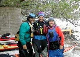
Finish Line!!! |
At 4:30AM, ASH woke us up, figuring the winds were as good as
they were going to get
and we ought to get started while the going was good. We started on
our way by 5:30,
limping on in, arriving at the finish at 8:30. There were still many
WaterTribers and
family members there to cheer us on. We could see them on the camp
beach as we
paddled into the Bay in front of the campground. What a feeling of
accomplishment!
Chief and others helped us out of our boats. It took about 30
minutes before the total
excitement and exhilaration allowed me to even think straight. Oddly
enough, I was
already thinking and looking forward to next year's Challenge.
After a shower and change of clothes, I enjoyed my celebratory
dinner (great leftovers
from the previous night's dinner), and Chief had an awards ceremony
for the 3 of us.
We each received our shark-tooth necklace (when the going got tough,
TW and I often
chanted "TOOTH, TOOTH, TOOTH") and our wooden paddle engraved with
the
WaterTribe logo and "Everglades Challenge", with space for a small,
engraved plaque.
What a personal accomplishment. But next year, I'm going for 2
teeth; challengers who
take the Wilderness Waterway route during the EC (which adds 30
miles to the total
distance) are awarded a shark took and a crocodile tooth.
Many months later, much of my adventure seems a blur. I have had
to use Paul's notes
from my daily reports to help write this report. I'm glad to have
this report as a reference
and as a way of sharing my adventure. I do remember what a great
time I had, an
incredible adventure, and how exciting it was. At the Captain's
meeting before the
Challenge, I thought Chief might have overheard me say "this is
going to be so much
fun". Later during his discussion, he said something to the effect
that "If you are doing
this because you think it will be fun, you will be in for a
surprise. This is not for fun". I
really thought he was speaking to me. It's true that at Checkpoint 1
on Sunday I
reported home, "I'm having so much fun!" and by Tuesday it seemed
more fitting to
report, "I'm having so much… adventure!" Nevertheless, throughout
the Challenge, I
was having the most fun, doing what I like the most, paddling and
camping. Even when
we were hurting and tired, we never once thought we could not or
would not finish the
trip.
In 2004 TW and I were the 2nd and 3rd women to ever finish the EC
in solo kayaks; the
1st was WateRose who finished in 2003. I consider this to be quite
an accomplishment,
an adventure I am very proud of. And, I can't wait for EC 2005, only
this time; it's for
two teeth.
|
SandyBottom and TurtleWoman - Key Largo |
© Dawn Stewart 2005
|